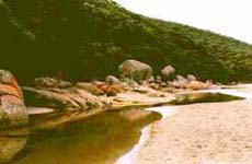
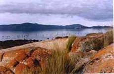
 Squeaky Beach Squeaky Beach |
 Tidal River Tidal River |
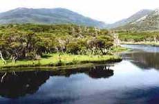 Tidal River Tidal River |
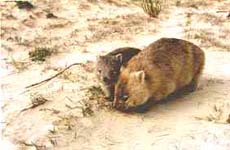 Wombats at Darby River Wombats at Darby River |
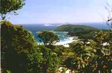
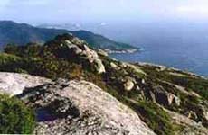 South from Mt.Oberon South from Mt.Oberon |
 |
|
SHORT WALKS
Cotters Beach - a track through swampy area (lake in wet season) to remote Cotters Beach - 1.2km each way
Millers Landing Nature Walk - starts at Five mile Road - banksia woodlands, fine views and mangrove flats - 2.0km
Squeaky Beach Nature walk - Start at Tidal River footbridge & cross Pillar Point to Squeaky Beach (Leonard Bay). Either back track or walk to the Squeaky Beach car park: 2km return (approx 30-40 mins each way)
Squeaky Beach to Picnic Bay - start at Squeaky Beach (make the sand squeak!), enjoy spectacular coastal views - 1.8km each way
Picnic Bay and Whisky Bay - short walking tracks to each beautiful beach from the car parks. Swimming not recommended
Mt.Bishop - start from Lilly Pilly Gully car park and climb a rough track to the summit for wonderful views of the coast - 3.5km
Lilly Pilly Nature Walk - from the car park experience the changing scenery of the last pockets of intact rainforest, down to the gully of Lilly Pilly's - 5km
Mt.Oberon Nature Walk - from the Mt.Oberon car park, follow the track (moderately steep) to the summit - 3.2km
Darby River and Beach - after crossing the bridge, follow a level track from the car park down to Darby River - this was the site of the original Darby River Chalet constructed in 1922, since demolished. 1km
Tongue Point - track starts at the Darby Saddle. Short side tracks lead to Sparkes Lookout and Fairy Cove. It may be easier to return to Darby River - so if planning ahead - arrange to leave a car there, or be dropped off at the start - 6.3km (3.5km to Darby River)
Sealers Cove - starting at Mt.Oberon car park, it leads to Windy Saddle an the on to the secluded Sealers Cove - 9.5km each way
Tidal River - There are also many short walks from this location eg.
Loo-Errn Track - 1km walk each way
Tidal River - Norman Bay - 0.5 - 1km walk
Whale Rock - 0.5km walk
South Norman Bay and Little Oberon Bay - walk 4km each way
For the Longer & Overnight walks on THE PROM -
refer to 'Park Notes' - available from 'Parks Victoria'
- permits are required & may need to be booked.
Please verify prior to departure
- weather conditions
- if tracks have changed
- tracks are closed to the public

Australia map |
|

Back |
LONG WALKS
Sealers Cove - a full day round trip walk from Mt Oberon car park. A superb 10km round trip which takes 2½ - 3 hours each way. This is an ideal walk for an overview of this remote location. Be sure to add at least one hour for exploring or to have a swim (on a warm day preferably!)
Overnight
The Lighthouse via Halfway Hut & Roaring Meg walk - Lighthouse has overnight accommodation. This walk takes you to the furthest reaches of the Prom - past Roaring Meg to the Lighthouse on the wild & windy South East Point. The scenery is spectacular in the last phases & its a pretty hard slog! So be fit... Distances on this walk are:
 Mt Oberon car park - Halfway Hut: 7.7km Mt Oberon car park - Halfway Hut: 7.7km
Hut to Roaring Meg: 5.6km
Roaring Meg to the Lighthouse: 5.5km
Continuing on from Sealers Cove
Sealers Cove - Refuge Cove: 6.5km
Refuge Cove - Waterloo Bay: 8km (on to Little Waterloo Bay)
Waterloo Bay - two routes can be taken to the Lighthouse - inland (walk through a swamp to the center of the Prom: 6.3kms) - or via the coastal route. If returning to Tidal River via inland track; once the Lighthouse track is reached, two option are available -
*head north back to the Mt Oberon car park, or
*head west crossing over the Lighthouse track to Tidal River via Oberon Bay route
|