|
The Australia Map |
History of an Ancient Land - Wilsons Promontoryincludes YANAKIE Peninsula/Isthmus history |
|
Wilsons Promontory or 'The Prom' has also been known as 'Wamoon', 'Yiruk' & 'Woomom'Wilsons Promontory National Park, or 'The Prom' as it is affectionately known, was one of the first National Parks in Victoria. It was temporarily reserved as a site in 1898, and was permanently declared after a long campaign by the 'Field Naturalists Club of Victoria' and the tourist industry in 1905, with the exemption of the coastline, which was later added in 1908, and finally extended from Darby River, northward to include half of the Yanakie Parish in the 1960's. Prior to the area being declared as a national park, the promontory had been divided off into various parishes under the county of Buln-Buln in the Shire of South Gippsland. These parishes included Beek-Beek, Warreen, Kulk, Tallang as well as Yanakie (all Koori names), with the full intention of future development. The town of Seaforth (at the foot of Mt.Hunter, [but also gazetted as the Township of Mt.Singapore in 1889]) was established in the parish of Wareen, and another at Sealers Cove (in 1854 with a population of 53 men and 8 women).More than 12,000 years ago, when the sea level was six metres higher than at present, 'The Prom' was a group of islands with only the mountain tips showing above water level. When the sea level dropped, (to form the land bridge to Tasmania), a series of sand dunes formed over a basalt base creating the Yanakie Isthmus, and so constructing a link between of the previous islands and the mainland. When the sea level rose again to its present level, the Yanakie Isthmus & Peninsula formed what is now the present day Wilsons Promontory
Wilsons Promontory was first traveled by the Koories (as south-eastern Australian Aboriginals prefer to call themselves). These people were of the Gunai (Kurnai) community with the Brataualung clan occupying the surrounding areas of South Gippsland. To the Koories, Wilsons Promontory is known as 'Wamoon', (also known as Yirik or Woomom), watched over by Since the time of European discovery, exploitation has vastly changed some of the land and the surrounding sea. One record of the extent of this is the impact on seal numbers - in 1804 the American ship 'Union' obtained 600,000 seal skins - today we have nowhere near this number in the whole of the southern Australian waters. When this industry collapsed they turned their attention towards harvesting the oil of mutton birds (short-tailed Shearwaters), and whaling. (Local timber was used for fuel to boil down the blubber) A mill was set up in Sealers Cove in 1849, but lasted only until 1858, when presumably all the accessible tall timber had been removed (a revival of the timber milling occurred again between 1903 to 1906, with a small town comprising 16 buildings, a boarding house and a community hall existed). Pastoral leases were granted from approximately 1851 onward in Sealers Cove and the Yanakie Isthmus/Peninsula, with varied successes. The Yanakie Run was a very profitable business, grazing from Darby River back to west of Paterson Road.
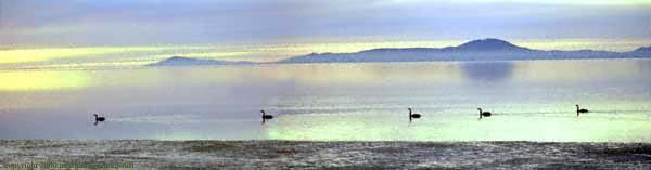
YANAKIE is always identified with Wilsons Promontory as it forms the peninsula and the isthmus, (thereby creating a Promontory and is the last town before entering the National Park. 'YANAKIE' (yan-a-key) - a Koori name from the Gunai (Kurnai) language interpreted generally as 'between waters' - Yanakie was one of the original parishes in the County of Buln-Buln on the Wilsons Promontory Peninsula, along with Beek-Beek, Warreen, Kulk and Tallang (all with the exception of the northern section of Yanakie being incorporated into the National Park over a period of time - 1905,1908 and the last section in the 1950's...). The northern section of Yanakie was probably exempted on the grounds of revenue, as a lease was granted in 1852 for the Yanakie Station or Run (a profitable business), which originally grazed cattle through to Darby River. Yanakie has only been developed into dairying country since the 1950's... Prior to development, Yanakie (also called the Yanakie Common) was open heathy plains with the 'Red Swamp', 'White Swamp and 'Black Swamps', supporting vast bird life including the black swans and brolgas. It is interesting to note that very few of the original Koori (aboriginal) names exist on the National Park today... Prior to European settlement, Yanakie was described as open heathy plains with areas of 'old man' banksias, stunted eucalypts, with tea-tree and paperbarks growing in the swamps, and she-oaks over the sand dunes. Today evidence of the original flora can still be seen along the coastal borders. In 1852 land granted to the settler, Richard Bennison, (from Darby River back through the Isthmus) was to become known as the 'Yanakie Run' or 'Yanakie Station'. In 1954, the Government Settlement Scheme cleared and subdivided the Peninsula & Isthmus. Unfortunately, when the swamps of this area (Red Swamp, Black Swamp and White Swamp) were drained during settlement, we lost vast nesting areas for many of the native bird life - particularly - the black swan, (some like the brolga - never to return). Today the area is very productive dairying country, surrounded by beautiful beaches and tidal flats. Yanakie Village is only a few minutes drive to Corner Inlet, Shallow Inlet & the Wilson Promontory National Park Gate. |
Australia map Web design, images & Maps - Copyright © 2001-2006 Clarke-Ruff 'Aussie map'. All rights reserved. |
Back |