|
The Australia Map |
INLETS, BEACHES & BAYS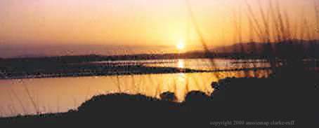
|
|
| Shallow Inlet - Yanakie beach access from Shallow Inlet - Sandy Point/Inlet Rd |
Corner Inlet - Yanakie beach access from |
Beach destinations on Waratah Bay Sandy Point - Waratah Walkerville North/South Bear Gully - Cape Liptrap Beaches & bays of Wilsons Prom |
This area to west of the promontory isthmus/peninsula was originally known as 'Shoal Inlet' or 'Shoal Lake'. Shallow Inlet is changing shape year by year, gradually meandering to its most easterly extreme, as the surging tides actively alter the shoreline and seabed. Given certain climatic conditions (wind direction, tide and rainfall), a new channel will form, recreating an area once referred to as the 'Blue Lagoon'.
Declared a Marine and Coastal Park in 1986 in recognition of the area's habitat values for migratory wading birds and shorebirds. At low tide 300 ha. of Shallow Inlet is covered by water. This changes to 1800 ha. at high tide - the equivalent of 32,000 Olympic swimming pools flowing in and out with the tide every 6 hours. It is strongly advised that small craft do not attempt to access the channel entrance to Waratah Bay, as it can become treacherous at tide change (lives have been lost). Beneath the water are extensive sea grass meadows, providing important nursery and fish breeding grounds. Care needs to be taken with power boats as serious damage can be inflicted on the fragile intertidal areas
Australia map |
Back |
Hourigan Camp Lane Walk - This section of 'The Prom' offers visitors long sandy beaches after a pleasant stroll through a sheltered gully. By walking quietly along the track, you may see and hear the various birds and animals in their natural habitat. The beach offers sandy tidal flats, where at low tide the channel is clearly visible and on high tide the Inlet is consumed by a vast sheet of water. The area forms part of the Shallow Inlet Marine and Coastal Park and is popular for fishing and windsurfing.
From Millar Road (see map) turn into - 'Hourigan Camp Lane', a short unmade road, and drive to the car park. Once you pass through the small gate, you are in Wilsons Promontory National Park. Follow the track along the boardwalk to the beach. Distance: 400metres/15mins one way - an easy walk through a natural bush track to Shallow Inlet beach.
Adams Road - after a little climb down to the beach, you will find yourself at the lower reaches of the Shallow Inlet channel. This vast area is the nursery and breeding ground of several fish species
Lester Road - at the end of this road was the site of the original guest house for those wishing to travel further into the Promontory. From this location, people would wait until low tide, then set off driving around the beach of Shallow Inlet, along Cotters Beach, finally making their way down to the 'Darby River Chalet' (now demolished). Here you will find a lovely beach side picnic area near the Shallow Inlet caravan park.
Australia map |
Back |
Named by Bass in February 1798, situated between the north-eastern shore of the promontory and the southern shore of Big Snake Island, with the extensive sheet of water and sandbanks of the Corner Basin lying between Wilsons Promontory and the mainland to the north. Several areas of very extensive intertidal mudflats of the coast and islands are covered with mangroves (the most southerly occurrence of Avicennia marina [White Mangrove] is found at Corner Inlet). This area is of international significance as a habitat for migratory wading birds
Duck Point Walk - Commencing on Foley Road, this trail leads through thickets of Coastal Tea-tree to the sheltered waters of Corner Inlet. Scenic views across the Inlet to the peaks of Wilsons Promontory are the feature of this walk. Distance 800 metres/30min return
Foley Road - the beach here has boat launching access. This area has public facilities & picnic area and is the site of the Yanakie caravan park
Yanakie Landing Walk - Starting at Foley Road the track wends its way down to the rocky beach area, then back up through the Old Quarry. Distance approximately a 1.3km circuit with some steep sections. The lookout has good views of Corner Inlet and over Mt.Singapore, Mt.Vereker, Mt.Margaret, Mt.Hunter, Mt.Roundback and Chinamans Knob
Shellcot Road - enter reserve area marked 'Red Bluff' and follow track to beach. It is very pleasant to walk in either direction, but to the right you will see the 'Red Bluff' jutting out. ('Red Bluff' is formed out of a very reddish clay) This is a very tidal area.
Bluff Road - Follow a very bushy track down to the boat sheds. This is a mangrove area and can be quite squelchy under foot. To the left, towards 'Red Bluff', the very rare 'Yanakie Berry ' (bright red berries with very prickly leaves) can be seen in fruit in the late Autumn and early Winter
Charles Hall Road - an excellent location for observing the pristine environment and habitat of many species of wading birds. This is a very fragile and significant location with its marshes and small creeks, so tread gently
Australia map |
Back |
|
WARATAH BAYon the Western side ofWILSONS PROMONTORY |
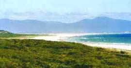
The Bay area is formed of 20 km of flat sparkling sandy beach and areas of rocky outcrops to the west as far as Cape Liptrap (its most western extreme) and Wilsons Promontory coastline to the east. The entrance to Shallow Inlet is at the north east of the bay, and forms a sandy spit which gives rise to the name of the township of Sandy Point. Sandy Point is safe beach for swimming, surfing and fishing, with boat launching facilities at Waratah and Walkerville. This whole area offers magnificent coastal scenery
SANDY POINT - located on Waratah Bay. The vast expanse of beach, with fine, soft sand is very safe for swimming, surfing and fishing. The township is nestled behind bushy sand dunes, with houses hidden amongst the tea tree on gently curving roads. During summer the beach is patrolled by the Sandy Point/Waratah Beach Surf Lifesavers. The township has a very well stocked Licensed General Store, the Sandy Point Cafe, (both offering takeaway), caravan park, public facilities, BBQ area, a children's playground and a mini golf course. Make sure to visit Shallow Inlet, only a few minutes away by car.
![]()
![]() Accommodation
Accommodation
WARATAH - a small village on Waratah Bay, originally referred to as 'the Gap'. Good for swimming, fishing & boat launching to Waratah Bay. Camping on the foreshore is no longer available. There are BBQ & public facilities & a caravan park
Back |
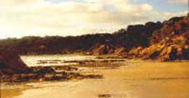
WALKERVILLE - Good fishing off the rocks. The best area for swimming is the beach at South Walkerville. The once small township and bustling port of Walkerville operated from 1875 to 1926, supplying quick lime to the Melbourne building industry. Today the kilns are in ruins, but there are still many reminders of the past as well as wonderful coastal landscapes, ancient rocks and diverse marine life. Walkerville North-South Link Track - this track links the north and south settlements if Walkerville through stands of Drooping She-oak and past the limestone cliffs and the ruins of four lime kilns. A short side track leads to the historic Walkerville cemetery. A visit to Bear Gully should also be considered when in this area.
BEAR GULLY - With views across Waratah Bay to Wilsons Promontory. Good for fishing, swimming, diving & snorkeling amongst the rock outcrops
CAPE LIPTRAP - the westernmost point of Waratah Bay, with it's steep rocky foreshore where there is a lighthouse/beacon. At night its light is visible, slowly flashing, for up to 34 km away (18 nautical miles)
Australia map Web design - Copyright © 2001-2006 Clarke-Ruff 'Aussie map'. All rights reserved. Photographs courtesy of 'Stardust Miracles' by Lois Rooke© & Clarke-Ruff© - all images © 1999 |
Back |