|
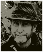
David E. Clarke (Dave) 24. 10. 1946 Artist David was born in Melbourne & educated at Scotch College. He was apprenticed into farming at the age of 17 as a Station Cadet (Jackeroo) on properties in the N.S.W Riverina where he gained broad experience which he now reflects in his Australian landscapes. Dave's animated map series, watercolour paintings and sketches have sold worldwide. |
|
Dave was originally approached at our Yanakie Gallery & Accommodation business in the early 1990's by travellers to Wilsons Promontory seeking places to visit while on holidays. Dave began doing maps of rural townships and popular regional areas for tourism purposes. This led to the drawing of several large maps, some commissioned & some purely for the love of doing them. The first map published was the South Gippsland Map (1994), with a second edition in 1996 and a third edition updated in 2021 to reflect regional changes. This style of map evolved from David drawing 'mud maps' for the traveler interested in discovering more about the local region. His artistic, animated and humorous style of drawings proved very popular to both local and international visitors. |
|
Five maps eventually completed the Gippsland Series; 1) South Gippsland, 2) Wilsons Promontory, 3) Phillip Island, 4) East Gippsland and Lakes Systems 5) East Gippsland/South-East NSW Dave and his partner Marianne sold the Yanakie Gallery/Tearoom/Accommodation business in 2000 to Kay Kennedy. Kay continues to sell the Gippsland Series of Maps. The Gipplsand Series was then followed by the AussieMap-Australia Map. This is the largest of all the maps produced and involved many months of research and even more in crafting the drawings. This map includes many interesting facts, quirky comments and information about this vast and beautiful country. Following requests for Dave to continue drawing maps around the Victorian coastline in 2006-07 the Port Phillip ~ Melbourne ~ Mornington Peninsula Map was produced. |
|
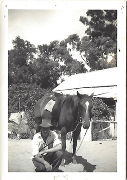
At the age af 17, Dave became a station cadet (Jackeroo) and later a station hand on large properties in New South Wales and eventually became a dairy farmer in the Eildon region of Victoria. Dave was fortunate to have entered the farming scene when horses, cross cut saws & hand milking were still part of the rural way of life; it was a time before automation changed the pace of life from one that offered a much more peaceful existence... albeit far more strenuous one. These experiences, along with his relationship to the "Bush" during its more romantic stages, formed memories Dave would always hold dear. The call of the outback then sent him on further exploits around Australia as a contract fencer on large stations and other farms. |
| After an accident and a marriage breakdown, David was obliged to use his talents as a self-taught artist to make a living. It was at this point that he began to draw on his affinity with the country he had come to know so well. It was not long before Dave gained a reputation for his evocative watercolour paintings, saucy sketches and bitingly funny cartoons - many of which have found their way all over the world. |
|
It is with these experiences in mind, the places he visited and the sights he saw, that have inspired this artist to produce his maps and artworks thast have become in many ways a personal and poignant journey of memories. |
|
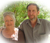
Dave and his artist partner, Marianne Ruff, moved from their Yanakie property overlooking Corner Inlet on the coast of Wilson's Promontory in 2012 and now live in Leongatha, South Gippsland Victoria. Dave's maps are all hand drawn and coloured and 100% produced and printed in Australia on high quality gloss paper. |